Le complément routage météo pour OpenCPN.
- Nota bene :
- Une grande partie des textes ci dessous sont en double version :
- En premier, version en Anglais, issue de l'aide du logiciel
- Juste en dessous, version en Français
- Les versions françaises, adaptées de l'Anglais, ne sont pas terminées et sont suceptibles de modification à venir.
Introduction
- The Weather Routing Plugin is designed to
compute iteratively positions the boat could possibly make at
a certain time. By merging the results of many calculations,
it is possible to form a map determining the best route
to any given location within the map.
- Le complément Météo-Routage est construit pour compiler,
itérativement, les positions que le bateau peut atteindre après un
certain temps. En réalisant plusieurs compilations, avec des paramètres
différents à chaque fois, on obtient peut en déduire la meilleure route.
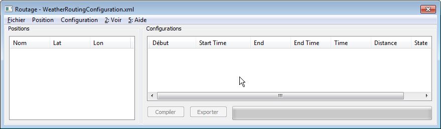
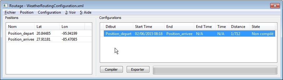
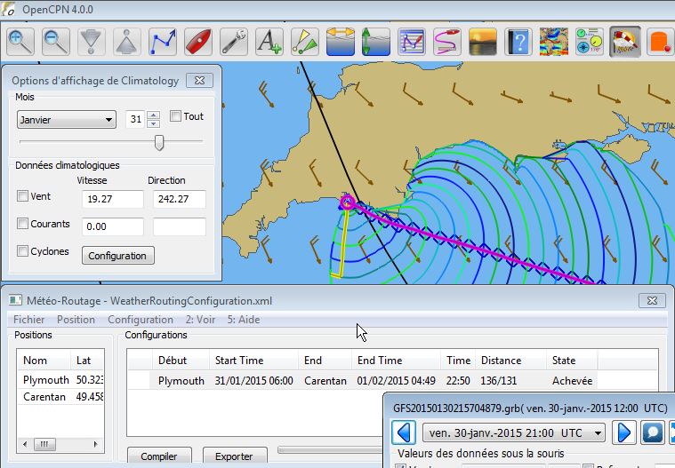
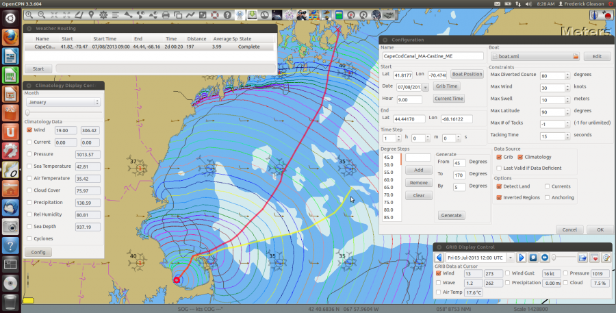
Démarrage rapide
-
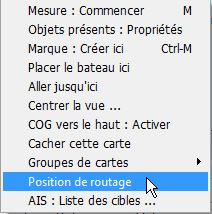
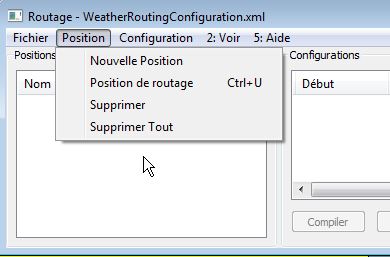
First, load the grib file used for routing using the grib plugin. Next,
open the Weather Routing plugin from the main toolbar and right click
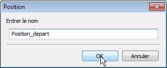
the map and Select "Weather Route Position" at the starting location.
Repeat this step for the destination. Now, in the Weather Routing
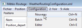
window from the Configuration menu (next to File) Select "New". From
here you must configure your vessel correctly in the boat dialog. When
ready, select "Compute" from the Configuration menu to compute the
weather route.
- En premier chargez un fichier grib utilisable avec le
complément Grib. Ensuite, lancez le complément Météo-Routage.
Définissez le point de départ par clic droit sur la zone de carte.
Répétez cette étape pour définir le point d'arrivée. Dans le menu de la
fenêtre de Météo-Routage, cliquez sur "Configuration" puis sur
"Nouveau". A partir de ce moment, vous devez configurer le bateau
correctement. Lorsque tout est prêt, cliquez sur "Compiler" dans le
menu "Configuration" pour que la compilation ait lieu.
Arrière plan
- Integration with the grib plugin (versioin 2.1 or later)
allows for
knowledge of weather conditions. The climatology plugin can also
provide a source of data for longer voyages, but be warned that using
the climatology data, especially in variable wind areas is unlikely
to give realistic results. Using climatology for currents is more
useful
and can be used with grib wind data when grib current data is not
available.
- L'utilisation du complément Grib (Version 2.1 ou plus
récente) permet d'exploiter les conditions météorologiques du moment.
Le complément Climatology fournit des données pour les voyage au long
cours. Mais, soyez prévenu que les données météorologiques de
Climatology, en particulier dans le cas de vent variable, risque de
donner des résultats peu réaliste. Par contre, l'utilisation de
Climatology pour les courants est plus crédible et peut être utilisé
lorsque les données sur les courants ne sont pas disponibles dans un
fichier grib.
-
For example, in the case where data is valid from both sources,
grib will always be choosen. If current data is available from
climatology,
and only wind from grib, then the grib wind is used with the
climatology current.
- Par exemple, si des données sont disponibles pour les deux
sources (Grib et Climatology), les données du fichier grib seront
utilisées prioritairement. Si les données relatives au courants sont
disponible dans Climatology et que le fichier Grib contient des données
vent mais pas de données courant, alors, Weather-Routing utilisera les
données vent de Grib et les données courant de Climatology.
- The grib time selected on the timeline at the time the
computation
is
started can be syncronized. From there, the grib timeline data is
accessed
as the computation proceeds. Once a computation is completed, the
course and position of the boat as it sails along the computed route
can be viewed during grib playback.
- ???
- Wind data is required; if no Current or Swell data is
available,
they are assumed to be zero.
- Les données vent sont requises. Si une des données vent ou houle est absente, elle est considérée comme égale à zéro.
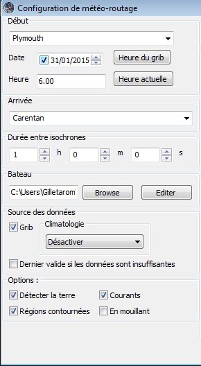
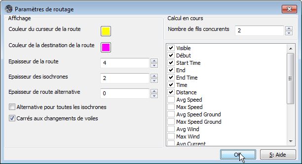
Les options de configuration
- Time Step
- Time to sail before considering a course
or sail
change. This is the difference in time between the isochrons on the
map. Small time-steps are needed to navigate through narrow channels
and give a more accurate result. Generally the route's computed time
becomes faster with smaller time steps as it can find a more optimal
route with more variation, however it will take longer to calculate
(generally 4 times longer for each time step doubling).
- Période de temps entre isochrones :
- Période de navigation envisagée sans avoir besoin de modifier le cap ou de faire un changement de voile(s).
- Une période courte convient pour les chenaux étroits qui nécessite une grande précision du résultat.
- La curée de la compilation est d'autant plus grande que
cette période est courte. Diviser la période par deux, exige,
généralement, quatre fois plus de temps de calcul par le PC.
- Grib
- Enable using current grib from grib plugin.
- Permettre l'utilisation des données grib disponible dans le complément Grib.
- Climatology
- Disable
- Do not allow climatology to be used.
- Bloquer
- Bloque l'utilisation des données météorologiques statistiques du complément Climatology
- Currents Only
- Use climatology for currents, but
never
wind.
- Courants seulement
- Utilisez Climatology pour les courants mais pas pour le vent.
- Cumulative Map
- Pretend the wind comes from all
of the
directions in the wind atlas for the percentage of time based on the
atlas. For this mode to work optimally, you should sail at all angles
from 0 to 360, and check "optimize tacking" in the vmg tab of the boat
dialog. This will allow the program to assume you will tack as needed
in intervals shorter than the isochrons to take advantage of wind
shifts.
- ????
- Cumulative - Calms
- Like Cumulative Map, except
the
boat also drifts without sailing during calms.
- Most Likely
- Use the interpolated most likely
wind data
from the wind atlas, with the most likely wind speed.
- ????
- Average
- Use wind vector average for wind
direction,
and wind magnitude average for wind speed. This is the fastest to
compute, but not very realistic (it may be close in prevailing
conditions).
- Utiliser, pour pour la direction du vent, la moyenne
des vecteurs vent et pour la vitesse du vent, la vitesse moyenne du
vent. Ceci permet la plus rapide compilation mais ce n'est pas réaliste
(Cela peut être acceptable dans certaines conditions).
- Désactiver
- Interdit l'usage du complément
Climatology. Les données connues à travers lui ne sont pas prises en
compte durant la phase de compilation.
- Currents Only
- Courant seulement
- Utiliser le complément Climatology uniquement pour les courants mais pas pour les vents.
- Cumulative Map
- Pretend the wind comes from all
of the
directions in the wind atlas for the percentage of time based on the
atlas. Dans cette conception des choses, vous pourrez naviguer sous
tous les angles par rapport au vent (i.e. de 0 à 360°), et cocher
"Optimiser les virements de bord" dans l'onglet de la boite de dialogue
de définition du bateau. Ceci permet au logiciel d'utiliser des
intervalles de temps plus courts que la période entre isochrones pour
tenir compte des changements de direction du vent.
- Cumulative - Calms
- Like Cumulative Map, except
the
boat also drifts without sailing during calms.
- ????
- Most Likely
- Use the interpolated most likely
wind data
from the wind atlas, with the most likely wind speed.
- ????
- Average
- Use wind vector average for wind
direction,
and wind magnitude average for wind speed. This is the fastest to
compute, but not very realistic (it may be close in prevailing
conditions).
- ????
- Allow Data Deficient
- Continuer de naviguer avec les dernières données
disponibles pour une zone et/ou une époque, même s'il n'y a plus de
donnée disponible.
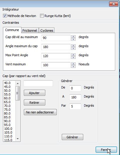
- Integrator Intégrateur
- La méthode de Newton est la méthode par défaut. Elle est
plus rapide Mais ne prends pas en compte les changement de vent ou de
courant au cours d'une étape.
- Rutta Kunge (4ème ordre) :
- Cette méthode est plus précise en effectuant 4 passes. Mais de ce fait, elle est plus lente.
- Toutefois, généralement, avec une petite période entre
isochrones, la méthode de Newton est recommandée parce que plus précise
que la méthode de Rutta Kunge.
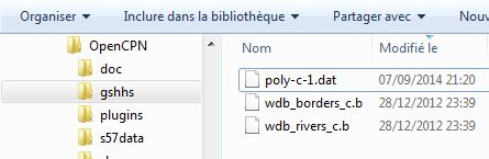
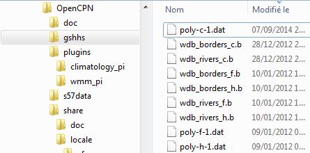
- Detect Land
- Détecter les terres :
- Utiliser les données de contours de côte GSHHS (pour
éviter de naviguer à travers les terres !). Ce choix entraine un
allongement du temps de compilation. Il est recommander de télécharger
le fichier du fond de cartes d'OpenCPN en haute résolution,
téléchargeable ici : Télécharger.
- Inverted Regions
- This is relatively rare, but in
some
cases it may be possible to reach a location from two different routes
(imagine either side of an island) which is further away from the
destination before the destination can be reached. At this point, the
algorithm must invert and work inwards on this inverted region (rather
than outwards) to possibly reach the destination. This case can occur
when routing around islands, or occasionally when routing near a high
pressure system. Normally this should be disabled, and extra
computations are avoided. NOTE: this mode has bugs
- Contournement de zones
- Il arrive parfois qu'il soit possible d'atteindre un
point en suivant deux itinéraires différents. Par exemple si le point
en question est de l'autre côté d'une île. Ou si une haute pression
barre la route du bateau. Dans ce cas, l'algorythme peut être
"inverseé" et travaille à l'envers pour atteidre le point prévu.
- L'emploi de cet options doit être rare pour éviter d'allonger inutilement le temps de compilation.
- Nota bene : De l'avis même du développeur, au 31/01/2015, cette option ne fonctionne pas bien.
- Anchoring
- In some cases, it may be preferable to
anchor
(assuming it isn't too deep) rather than continue to navigate if there
is a contrary current which is swifter than the boat can travel. This
allows the route to reach the destination sooner by sitting in place
until the current abades.
- En mouillant
- Dans certains cas, il peut être préférable de mouiller
(en supposant qu'il n'y ait pas trop de profondeur d'eau) plutôt que de
continuer à naviguer, s'il y a un courant contraire que la vitesse du
bateau empêche de remonter. Ceci permet de permettre d'atteindre la
destination plus tôt en mouillant sur place jusqu'à ce que le courant
faiblisse et/ou se renverse.
- Max Diverted Course
- Maximum course error to continue
toward destination. Not all possible courses will be considered and
therefore the most optimal route may not be found. This usually (but
not in all cases) is obvious when the optimal route is sometimes near
the edge of the graph. Using a reasonable value can greatly speeds the
rate of computation.
- Ecart max autorisée du COG
- C'est la différence de "route fond" acceptable par
rapport à la route directe.Toutes les directions possibles ne seront
pas étudiées. Et par conséquent, la meilleure route ne sera peut être
pas déterminée. Ceci est généralement évident (mais pas toujours)
lorsque la meilleure route est au bord de la carte marine.
L'utilisation d'une valeur raisonnable peut accélérer grandement la
compilation.
- Max Course Angle
- Like Max Diverted Course, except
the
search range is based from the starting position to the destination.
Normally should be set to 180.
- Secteur angulaire global de la zone de navigation
- La zone de navigation est définie par ce secteur. Le sommet est le
point de départ de la météo-route. Normalement, ce devrait être 180°.
- Max Search Angle
- This specifies how much the boat
course
can change between propagations. A value of 180 gives the maximum
flexibility of boat movement, but increases the computation time. A
minimum of 90 is usually needed for tacking, a value of 120 is
recommended with strong currents. Smaller values (60 or less) can give
very fast results, but should be used with care, as if the other
settings are not appropriate, an inaccurate graph will result. For
example, if tacking is needed at any time, then in this case, all
courses (0-360) must be specified as degree steps and the boat polar
optimized for tacking (see below: VMG tab of boat dialog)
- Secteur angulaire local
- Ceci spécifie dans quel secteur angulaire, le recherche se fera
durant la propagation d'une isochrone à la suivante. Une valeur de
180° donne un maximum de flexibilité mais augmente la durée de la
compilation. Un minimum de 90° est normalement nécessaire pour
atteindre le but. Une valeur de 120° est recommandée en cas de violents
courants. Une valeur plus petite (60°) peut conduire à une compilation
très courte mais doit être utilisée avec prudence. C'est comme si les
autres paramètres n'étaient pas appropriés et cela peut conduire à une
route inadaptée. Si tous les angles de recherche sont nécessaires, tous
les angles (0-360) doivent être exploités. (Voir ci dessous l'onglet
VMG de la boite de dialogue du bateau)
- Max Wind Knots
- Do not navigate in areas with more
wind
than this value.
- Vitesse maxi du vent (Noeuds)
- Ne jamais naviguer avec une vitesse du vent supérieure à cette vitesse.
- Max Swell Meters
- Do not attempt to navigate in areas
with
more wave average height than this value.
- Houle maximale (Mètres)
- Ne jamais accepter de naviguer si la houle est supérieure à cette hauteur.
- Max Latitude
- Do not navigate above (or below in the
southern hemisphere) this latitude.
- Latitude maximale
- Ne jamais monter au dessus de cette latitude tant dans l'hémisphère nord, ou descendre en dessous dans l'hémisphère sud.
- Max # of Tacks
- Does not attempt to tack more than
this
number of times. Currently it tacks as much as it likes initially, then
stops tacking at the limit, therefore if a very low number or an
even/odd mis-match is given, a very sub-optimal track may be produced.
For this reason a value of -1 (unlimited tacks) is recomended
- Nombre maximal de virements de bord
- Nombre maximal de virements de bord acceptés pas
autoriser. La valeur "-1" autorise un nombre infini de virements de
bord. Si une valeur faible est choisie ou si un nombre trop
dissymétrique de virements (bâbord amure/tribord amure) est obtenu, la
route déterminée peut ne pas être optimale.
- Tacking Time
- Penalty for course change from one tack
to
the other in seconds. This is normally irrelevant for ocean passages,
but could be useful for routes in tight quarters Setting to 0 avoids
extra calculations.
- Durée entre virements de bord
- Cette option permet de gérer la fréquence des virements de bord . Des virements trop fréquents ne sont pas pertinents pour les grandes traversées. Mais cela peut utile pour les itinéraires dans une zone de navigation exigüe. En choisissant la valeur 0, on évite des calculs supplémentaires.
- Wind VS Current
- When wind opposes current rough seas
can
be produced. This constraint takes the dot product of the current and
wind vectors, and if the result exceeds this value, navigation in this
area is avoided. Eg, a value of 20 would avoid 10 knots of wind opposes
a 2 knot current. Higher values allow for rougher conditions; the
special value 0 (default) allows any conditions.
- Vent contre Courant
- Lorsque le vent et le courant ont des directions
contraires, la mer peut devenir grosse. Si le produit scalaire du
vecteur vitesse du vent et du vecteur vitesse du courant dépasse la
valeur choisie ici, la navigation dans cette zone sera empêchée. Par
exemple, pour la valeur de 20, un vent de 10 noeuds et un courant
opposé de 2 noeuds auront comme produit scalaire la valeur -20. Au dela
de cette valeur, la météo-route ne passera pas dans cette zone. Pour
mettre cette contrainte hors service, utilisez la valeur 0.
- Eventuellement, lire cette page au sujet du produit scalaire de deux vecteurs : Produit_scalaire
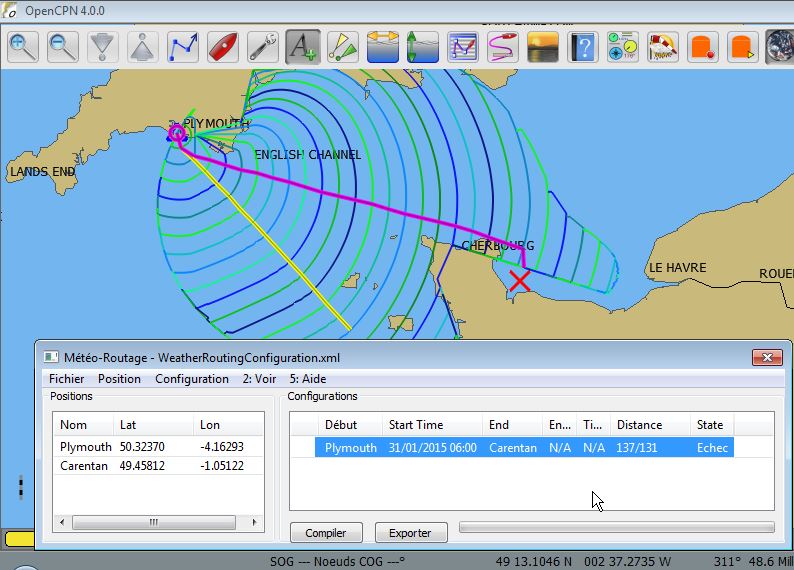
- Avoid Cyclone Tracks
- Uses climatology cyclone tracks
to
avoid routings which cross historic cyclones. The settings in the
climatology configuration for windspeed, pressure elnino etc are used,
so only visible tracks are considered.
- Eviter les traces de cyclones
- L'utilisation des traces des cyclones, présentes dans le
complément Climatology, empêche la route de croiser les traces déjà
connues. Les réglages de Climatology pour la vitesse du vent, la
presion, el ninio, tc ... sont pris en compte. De ce fait, seule les
traces rendues visibles par Climatology sont considérées.
- Courses (relative to true wind)
- A list of courses to
attempt sailing. Excluding certain values can force the route to
explicity show tacks/jibes. Another option is to remove all upwind
values to find a course which is always running off the wind (even if
it is much longer.) Good results typically have a course every 3-5
degrees; more steps takes longer computation time.
- Cap (Relatif au vent vrai)
- Une liste de cap à tester (??). Certaines valeurs peuvent conduire à montrer explicitement les virements de bord et/ ou les empannages. Une autre option consiste à supprimer toutes les valeurs au vent pour trouver un cap toujours sous le vent (même si la météo-route est beaucoup plus longue.) De bons résultats sont généralement obtenus avec un cap tout les 3-5 degrés ??). Ceci ajoute des étapes et demande plus de temps de compilation.
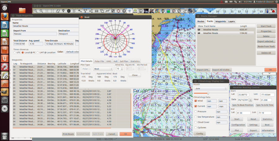
Traitement par lots
- Once a weather route is successfully computed, it is possible
to
determine the best time to leave. To do this, many configurations must
be generated each with a different start time. Starting by selecting a
single configuration with the earliest starting time. From the
configuration menu, select batch (ctrl+b) From here, enter the number
of days/hours to generate spans. Using decimal values for hours is
allowed (ie: 0.5 for half-hour) Once generate is selected, many
configurations should appear. Now, "Compute All (ctrl+a)" can be
selected from the configurations menu. A total progress bar can be seen
under the configurations. Finally a report describing the routes is
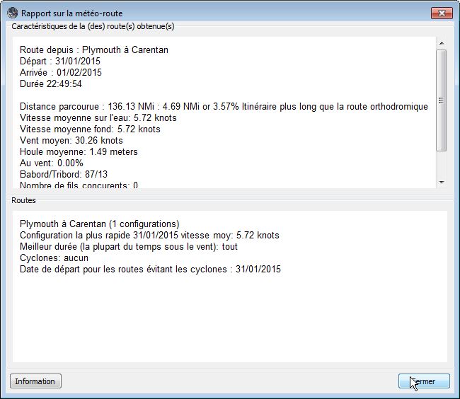
available from the View menu.
- Une fois qu'une météo-route a été compilée avec succès, il
est possible de déterminer la plus courte en durée. Pour obtenir ceci,
plusieurs configurations doivent être essayées, toutes avec différents
horaires de départ. En commençant par sélectionner la configuration
pour la plus matinale. A partir de cette configuration, sélectionner le
traitement par lot. Entrer un nombre de jours/heures pour générer les
météo-routes. En utilisant les valeurs décimales pour les horaires
permis, une météo-route est générée si elle est sélectionnée. Puis,
utilisez "Compiler tout" dans le menu "Configuration". Une barre de
progression est alors visible sous les configurations. Finalement, un
rapport est accessible, décrivant les météo-routes, en ouvrant l'item
"Voir".
Le bateau
-
The boat dialog displays the polar plot of the boat's speed vs true
wind direction as well as showing other details. An xml file specifies
the boat parameters and each sail plan. Two file types of polars are
supported; CSV (same as qtVlm) and xml parameters which describe how to
compute the polar.
- A partir d'un unique fichier de poaliers du bateau, la fenêtre "Bateau" affiche la courbe représentative de la vitesse du bateau en fonction de l'angle du vent réel, ainsi que d'autres détails. Et ceci, soit en coordonnées polaires, soit en coordonnées rectangulaires. Un fichier XML spécifie les paramètres de bateau et chaque configuration de la voilure. Deux types de fichiers de polaires sont pris en charge : CSV (même que qtVlm) et xml..
Onglet des données relatives au bateau
- specifies the parameters for the plot displayed.
- Polar Typical polar diagram showing boat speeds at
a
given wind speed.
- Speed Plot boat speed across all wind speeds at a
given
wind angle.
The tracking displays give data based on the mouse position over the
plot.
Onglet de configuration de la polaire
Configure the polar data to use. Either Compute with various
parameters, or specify a CSV file which contains a table of boat speeds
for all possible true wind speeds and directions.
Onglet VMG (Vitesse la meilleure)
Shows the best courses for up and down wind on each tack for
a
given true windspeed. Optimize Tacking makes the polar reflect these
tacking options on the relevant courses. If this option is chosen, then
the boat will assume the ability to sail in these angles (it is assumed
the captain will tack periodically to maintain any course.) If tacking
is not optimized, then weather routing will tack only at the isochrons,
resulting in overlapping alternate routes, and potentially slightly
less optimal course (but will specifically display where to tack.) It
also may take significantly longer to compute courses in areas with
rugged coastlines.
Switch Plan Rules
It is possible to specify several sail plans (ie spinnaker or
not)
and then for each plan make a rule for when it is appropriate to switch
to a different sail plan.
Statistiques
Displays miscellaneous statistics about the boat.
Information sur les performance du bateau
Most users should measure their boat performance (speed at
each wind
speed and direction relative to true wind) and load a CSV polar file of
these records instead of computing them automatically. In the future,
the computations could be greatly improved with more parameters to
yield more accurate results.
It is also possible to compute boat polar from an augmented
sailboat
transform calculation.
The original sailboat transform:
 2
 / sin(A/2) \
 sin(W) sin(A) | ---------- | = VW eta
 \ sin(W - A) /

W is true wind angle
A is apparent Wind angle
VW is true wind speed
eta is a boat specific constant specifying it's sailing efficiency.
Solving for boat speed based on apparent wind we get:
 __
 A /VA
VB(t) = sin (-) /---
t->inf 2 \/ eta
This computation is very useful for the standard rig, but doesn't
really apply correctly in many cases. It also doesn't really factor in
a huge range of variables as there is only one constant.
I have augmented the sailboat transform to also take into
account
two types of drag in the hope that it may come closer to resembling the
sailing characteristics of more vessels. This way hull speed is
properly taken into account, and for boats with planing ability, you
may get the right result if the correct values are used.
The Frictional drag reduces the maximum speed based on the
square of
its speed. The Wake drag component uses a complex math formula to
compute the energy lost creating a wake:
 2
 / sin(Pi - F^-2) \
 Drag = | ----------------------- |
 \ (Pi - F^-2) (1 + Pi F^2) /

 ___
 V = F * \/g l

 F = sqrt(g * l) / V;

 g = 9.8 (gravity constant)
 l is length of vessel in meters
 V is meters per second

 Reaches a peak at F=Pi^-.5 which is about .56

 The huge increase starts at F = .4 (normal hull speed setting)

 Also interesting to note that at 80% of normal hull speed, the wave
 drag is zero as well, but the first hump occurs from .32 to .4, and
 therefore causes more drag than right at .4.

 In theory, this equation is correct for wave drag for all speeds, from displacement to planing mode.
The basic polar describing boat speed at various wind settings
fails
on many fronts.
First of all, various sail combinations become impractical in certain
sea states,
even if the actual wind speed is the same. The boat also does not sail
the same
speed in these cases, so the actual boat speed may widely vary with
identical wind
speed/direction values in different sea states. Secondly, the wind is 3
dimensional,
and near land often has a noticable vertical component not accounted
for.
Thirdly, there may be certain areas conditions, or times when the user
may
selectively want to use a different polar diagram
(sail plan, navigating in fog or near ice, night vs day, autopilot vs
wind vane)
Fourthly, the actual speed of the boat may change due to various
parameters besides
currents, wind, and sea state. (more on this below) There are many more
reasons as well.
There is also extension for the possibility of other sources
of
propulsion
besides wind power (namely PV-solar electric, and/or human power both
which I use for
navigation when wind is unavailable) These are normally used in
conjunction with sails.
This form of power falls into the category of weather routing as it is
dependent on solar radiation
for photovoltaics, and temperature (sculling a yacht in tropical heat
has less range than
in cooler weather). It may be possible to consider storing generated
electrical power
(one possible case would be charging batteries with a hydro tow
generator sailing in strong winds,
this energy is then to be used the next day when the calm sets in) in
an electric drive it is possible
to reach the final destination at a sooner time than without this
consideration.
(all of this is mostly still unimplemented)
It is also possible to factor slow changing, but important
changes
to the boat's
passage-making ability over the course of the voyage. One example is
bottom growth,
and the rate it might grow given the sailing course and various
parameters. This
would enable you to gauge how essential it is to actually paint a
bottom, or if
you don't mind (as I have done many times) to clean your bottom in the
middle
of the ocean, you could calculate how much time it would save
(hopefully more
than the time spent scraping the growth off). There is also the case of
sails losing shape, and
becoming less efficient over the course of a very long passage.
Liste du Todo :
- Improve boat polar computation
- Optimize ll_gc_ll
- Optimize climatology wind atlas
- implement depth and overhead height from vector charts
- fix runge kutta for grib to use the right timeslices
- Fix issues where routes are not fully normalized
- Fix merdian problem, so we split the world on the opposite
of end
longitude, and don't propagate past it
- User option for grid reduction resolution?
- Determine best way way to reduce excessive propagations at
the
edge of graph
- Make segment intersection test smarter and thus avoid
deleting
points in almost all cases
- Fix inverted region anomallies, analyze child routes, and
remove
if end is not contained
- Optimize end calculation by using only positions which are
parents of non-propagated positions
- Make position removal avoid rebuilding skip list
Le complément Weather Routingest développé par Sean D'EpagnierS'il vous plait, contactez le pour lui poser vos questions, lui suggérer des évolutions et faire vos retours d'expérience. |
Up
Up
Up
Up
Up
Up
Up
Up
Up
Up
Up
|
 Version
pdf imprimable
Version
pdf imprimable